


odette

Charignon
User
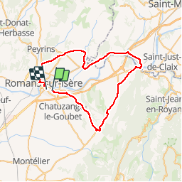

Length
51 km

Max alt
439 m

Uphill gradient
520 m
Km-Effort
58 km

Min alt
139 m

Downhill gradient
523 m
Boucle
No
Creation date :
2019-05-21 07:04:55.888
Updated on :
2019-05-21 10:01:36.464
2h50
Difficulty : Very easy

FREE GPS app for hiking
 SityTrail
IGN / Geographical institutes
SityTrail Plus
The world is yours!
About
Trail Road bike of 51 km to be discovered at Auvergne-Rhône-Alpes, Drôme, Chatuzange-le-Goubet. This trail is proposed by Charignon.
Positioning
Country:
France
Region :
Auvergne-Rhône-Alpes
Department/Province :
Drôme
Municipality :
Chatuzange-le-Goubet
Location:
Unknown
Start:(Dec)
Start:(UTM)
663061 ; 4988845 (31T) N.
Comments