


rando du 31/07

rafa77
User
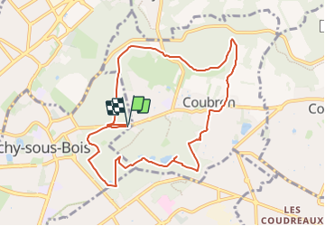

Length
9.3 km

Max alt
124 m

Uphill gradient
119 m
Km-Effort
10.9 km

Min alt
67 m

Downhill gradient
119 m
Boucle
Yes
Creation date :
2014-12-10 00:00:00.0
Updated on :
2023-06-28 05:57:57.221
2h28
Difficulty : Medium

FREE GPS app for hiking
 SityTrail
IGN / Geographical institutes
SityTrail Plus
The world is yours!
About
Trail Walking of 9.3 km to be discovered at Ile-de-France, Seine-Saint-Denis, Clichy-sous-Bois. This trail is proposed by rafa77.
Positioning
Country:
France
Region :
Ile-de-France
Department/Province :
Seine-Saint-Denis
Municipality :
Clichy-sous-Bois
Location:
Unknown
Start:(Dec)
Start:(UTM)
468059 ; 5417943 (31U) N.
Comments