


cassagnas. curriere

Catherine_Castel
User
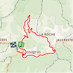

Length
19.1 km

Max alt
1136 m

Uphill gradient
607 m
Km-Effort
27 km

Min alt
697 m

Downhill gradient
605 m
Boucle
Yes
Creation date :
2019-05-21 07:28:47.413
Updated on :
2019-05-21 15:02:23.713
7h13
Difficulty : Medium

FREE GPS app for hiking
 SityTrail
IGN / Geographical institutes
SityTrail Plus
The world is yours!
About
Trail Walking of 19.1 km to be discovered at Occitania, Lozère, Cassagnas. This trail is proposed by Catherine_Castel.
Positioning
Country:
France
Region :
Occitania
Department/Province :
Lozère
Municipality :
Cassagnas
Location:
Unknown
Start:(Dec)
Start:(UTM)
558342 ; 4902268 (31T) N.
Comments