


amay

Steinier
User
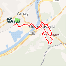

Length
7.5 km

Max alt
172 m

Uphill gradient
124 m
Km-Effort
9.2 km

Min alt
60 m

Downhill gradient
124 m
Boucle
Yes
Creation date :
2019-05-21 17:04:10.072
Updated on :
2019-05-21 18:06:49.327
1h02
Difficulty : Very easy

FREE GPS app for hiking
 SityTrail
IGN / Geographical institutes
SityTrail Plus
The world is yours!
About
Trail Running of 7.5 km to be discovered at Wallonia, Liège, Amay. This trail is proposed by Steinier.
Positioning
Country:
Belgium
Region :
Wallonia
Department/Province :
Liège
Municipality :
Amay
Location:
Amay
Start:(Dec)
Start:(UTM)
664250 ; 5601713 (31U) N.
Comments