Trail Walking Bagnoles-de-l'Orne-Normandie - Bagnoles-de-l-orne-vallee-de-la-cour-36 - Photo

Bagnoles-de-l-orne-vallee-de-la-cour-36

 plclq
plclq

User

© OpenStreetMap contributors
Length
Length
13.3 km
Max alt
Max alt
224 m
Uphill gradient
Uphill gradient
174 m
Km-Effort
Km-Effort  
15.6 km
Min alt
Min alt
177 m
Downhill gradient
Downhill gradient
176 m
Boucle
Boucle
Yes
Creation date :
2019-05-20 09:57:08.497
Updated on :
2019-05-22 09:45:47.033

(0 Reviews)

Walking
Walking
3h24
Difficulty : Very easy

Scan this QR Code to open this trail in the SityTrail application

FREE GPS app for hiking

Logo SityTrail SityTrail

IGN / Geographical institutes

Download SityTrail from the App Store Download SityTrail from Google Play

Logo SityTrail SityTrail World

The world is yours!

Download SityTrail from the App Store Download SityTrail from Google Play Download SityTrail on Huawei AppGallery

About

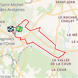
Trail Walking of 13.3 km to be discovered at Normandy, Orne, Bagnoles-de-l'Orne-Normandie. This trail is proposed by plclq.

Description

En partie samedi

Elevation profile

Points of interest

Point of interest Bagnoles-de-l'Orne-Normandie - N°8 - Photo
plclq
BAGNOLES-DE-L'ORNE-NORMANDIE 
Point of interest La Ferté-Macé - N°7 - Photo
plclq
LA FERTÉ-MACÉ 
Point of interest Bagnoles-de-l'Orne-Normandie - N°6 - Photo
plclq
BAGNOLES-DE-L'ORNE-NORMANDIE 
Point of interest La Ferté-Macé - N°5 - Photo
plclq
LA FERTÉ-MACÉ 
Point of interest La Ferté-Macé - N°4 - Photo
plclq
LA FERTÉ-MACÉ 
Point of interest La Ferté-Macé - N°3 - Photo
plclq
LA FERTÉ-MACÉ 
Point of interest Bagnoles-de-l'Orne-Normandie - N°2 - Photo
plclq
BAGNOLES-DE-L'ORNE-NORMANDIE 
Point of interest Bagnoles-de-l'Orne-Normandie - N°1 - Photo
plclq
BAGNOLES-DE-L'ORNE-NORMANDIE 

Positioning

Country:
France
Region :
Normandy
Department/Province :
Orne
Municipality :
Bagnoles-de-l'Orne-Normandie
Location:
Bagnoles-de-l'Orne
Start:(UTM)
690895 ; 5381550 (30U) N.

Trails nearby

Trail On foot Rives-d'Andaine - Sentier des Templiers - Photo
On foot
PRO

On foot

Easy
Rives-d'Andaine, Normandy, Orne, France
4.9 km | 6.2 km-effort
1h 23min
No
Trail Walking Bagnoles-de-l'Orne-Normandie - Saint Ortaire - Photo
Walking
tracegps

Walking

Difficult
(1)
Bagnoles-de-l'Orne-Normandie, Normandy, Orne, France
5.5 km | 6.9 km-effort
1h 39min
Yes
Trail Walking Bagnoles-de-l'Orne-Normandie - Forêt d'Andaine - Photo
Walking
Martine_59150

Walking

Easy
Bagnoles-de-l'Orne-Normandie, Normandy, Orne, France
3.6 km | 4.2 km-effort
2h 0min
No
Trail On foot Bagnoles-de-l'Orne-Normandie - Les Arbres remarquables de Bagnoles-de-l'Orne - Photo
On foot
PRO

On foot

Easy
Bagnoles-de-l'Orne-Normandie, Normandy, Orne, France
7.7 km | 9 km-effort
2h 2min
Yes
Trail On foot Bagnoles-de-l'Orne-Normandie - Bagnoles-de-l'Orne - Photo
On foot
PRO

On foot

Easy
Bagnoles-de-l'Orne-Normandie, Normandy, Orne, France
8.2 km | 9.7 km-effort
2h 11min
No
Trail On foot La Ferté-Macé - Circuit des Bornes Cavalières - Photo
On foot
PRO

On foot

Easy
La Ferté-Macé, Normandy, Orne, France
8 km | 9.5 km-effort
2h 10min
No
Trail Hybrid bike Bagnoles-de-l'Orne-Normandie - bagnoles de l'ore - Photo
Hybrid bike
valetg

Hybrid bike

Easy
Bagnoles-de-l'Orne-Normandie, Normandy, Orne, France
18.6 km | 22 km-effort
1h 41min
Yes
Trail Walking Magny-le-Désert - Andaines - Villiers - Photo
Walking
lolomilastef

Walking

Medium
(1)
Magny-le-Désert, Normandy, Orne, France
10.6 km | 13.6 km-effort
2h 36min
Yes
Trail Walking Bagnoles-de-l'Orne-Normandie - Bagnoles de l' orne - Photo
Walking
MichelRando7656

Walking

Very easy
Bagnoles-de-l'Orne-Normandie, Normandy, Orne, France
4.8 km | 6.1 km-effort
1h 49min
Yes


Close
My subscriptions