


crête de ramiat

ymobernard
User
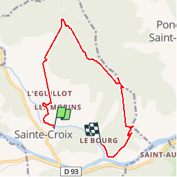

Length
7.3 km

Max alt
895 m

Uphill gradient
546 m
Km-Effort
14.6 km

Min alt
360 m

Downhill gradient
548 m
Boucle
No
Creation date :
2019-05-22 07:45:02.935
Updated on :
2019-05-22 12:58:54.743
3h40
Difficulty : Very easy

FREE GPS app for hiking
 SityTrail
IGN / Geographical institutes
SityTrail Plus
The world is yours!
About
Trail Walking of 7.3 km to be discovered at Auvergne-Rhône-Alpes, Drôme, Sainte-Croix. This trail is proposed by ymobernard.
Positioning
Country:
France
Region :
Auvergne-Rhône-Alpes
Department/Province :
Drôme
Municipality :
Sainte-Croix
Location:
Unknown
Start:(Dec)
Start:(UTM)
680869 ; 4959910 (31T) N.
Comments