


boucle-lampersloch-four-a-chaux

anniston
User
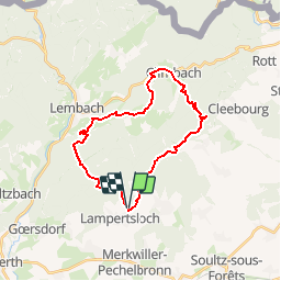

Length
24 km

Max alt
483 m

Uphill gradient
681 m
Km-Effort
33 km

Min alt
210 m

Downhill gradient
688 m
Boucle
Yes
Creation date :
2019-05-24 12:33:57.58
Updated on :
2019-05-24 21:16:39.824
4h19
Difficulty : Difficult

FREE GPS app for hiking
 SityTrail
IGN / Geographical institutes
SityTrail Plus
The world is yours!
About
Trail Horseback riding of 24 km to be discovered at Grand Est, Bas-Rhin, Lampertsloch. This trail is proposed by anniston.
Positioning
Country:
France
Region :
Grand Est
Department/Province :
Bas-Rhin
Municipality :
Lampertsloch
Location:
Unknown
Start:(Dec)
Start:(UTM)
413842 ; 5423903 (32U) N.
Comments