


sur les traces de Pagnol fait

LouisROGER
User GUIDE
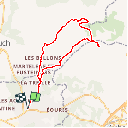

Length
18 km

Max alt
692 m

Uphill gradient
781 m
Km-Effort
28 km

Min alt
100 m

Downhill gradient
781 m
Boucle
Yes
Creation date :
2019-05-25 06:45:19.552
Updated on :
2019-05-25 14:14:31.692
7h12
Difficulty : Very easy

FREE GPS app for hiking
 SityTrail
IGN / Geographical institutes
SityTrail Plus
The world is yours!
About
Trail Walking of 18 km to be discovered at Provence-Alpes-Côte d'Azur, Bouches-du-Rhône, Marseille. This trail is proposed by LouisROGER.
Description
le 25 mai 2019
Photos


Positioning
Country:
France
Region :
Provence-Alpes-Côte d'Azur
Department/Province :
Bouches-du-Rhône
Municipality :
Marseille
Location:
11th Arrondissement
Start:(Dec)
Start:(UTM)
703171 ; 4797432 (31T) N.
Comments