


Lac des Pises

ARVIEU
User

Length
17.8 km

Max alt
1368 m

Uphill gradient
796 m
Km-Effort
28 km

Min alt
665 m

Downhill gradient
792 m
Boucle
Yes
Creation date :
2019-05-25 14:29:18.134
Updated on :
2019-05-25 14:53:23.805
5h50
Difficulty : Very difficult

FREE GPS app for hiking
 SityTrail
IGN / Geographical institutes
SityTrail Plus
The world is yours!
About
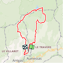
Trail Walking of 17.8 km to be discovered at Occitania, Gard, Arrigas. This trail is proposed by ARVIEU.
Description
Départ de Vernes vers le lac des Pises par le col de l ‘Homme Mort, retour par le col des Portes, Montloutiers, les Vernedes.
Positioning
Country:
France
Region :
Occitania
Department/Province :
Gard
Municipality :
Arrigas
Location:
Unknown
Start:(Dec)
Start:(UTM)
539764 ; 4871683 (31T) N.
Comments