Trail Walking Saint-Loup-Terrier - st loup terrier - Photo
© OpenStreetMap contributors
Length
Length
9.7 km
Boucle
Boucle
Yes
Creation date :
2019-05-25 12:01:31.29
Updated on :
2019-05-25 15:32:05.455

(0 Reviews)

Walking
Walking
2h15
Difficulty : Medium

Scan this QR Code to open this trail in the SityTrail application

FREE GPS app for hiking

Logo SityTrail SityTrail

IGN / Geographical institutes

Download SityTrail from the App Store Download SityTrail from Google Play

Logo SityTrail SityTrail World

The world is yours!

Download SityTrail from the App Store Download SityTrail from Google Play Download SityTrail on Huawei AppGallery

About

Trail Walking of 9.7 km to be discovered at Grand Est, Ardennes, Saint-Loup-Terrier. This trail is proposed by gilbertwarin08.

Description

Rethel rando.  
25/05/2019

Elevation profile

Positioning

Country:
France
Region :
Grand Est
Department/Province :
Ardennes
Municipality :
Saint-Loup-Terrier
Location:
Unknown
Start:(UTM)
616878 ; 5492870 (31U) N.

Trails nearby

Trail Walking La Sabotterie - De la Sabotterie à Jonval - Photo
Walking
tracegps

Walking

Medium
La Sabotterie, Grand Est, Ardennes, France
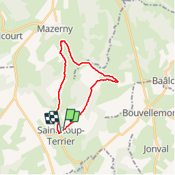
11.5 km | 13.7 km-effort
2h 45min
Yes
Trail Walking Tourteron - Les Vergers du Tourteronnais - Photo
Walking
tracegps

Walking

Medium
Tourteron, Grand Est, Ardennes, France
17 km | 21 km-effort
3h 30min
Yes
Trail Horseback riding Saint-Loup-Terrier - Balade du 13/07 - Photo
Horseback riding
Eva Chevallier

Horseback riding

Saint-Loup-Terrier, Grand Est, Ardennes, France
5.4 km | 6.7 km-effort
52min
No
Trail Other activity Baâlons - balade entre beauvois chagny et omont - Photo
Other activity
jacottinf

Other activity

Easy
Baâlons, Grand Est, Ardennes, France
18.2 km | 23 km-effort
1h 58min
Yes
Trail Other activity Baâlons - jacottin  - Photo
Other activity
jacottinf

Other activity

Easy
Baâlons, Grand Est, Ardennes, France
18.2 km | 23 km-effort
1h 58min
Yes
Trail sport La Sabotterie - Vac 2023 - étape 3 - Photo
sport
adelemarteau

sport

Very easy
La Sabotterie, Grand Est, Ardennes, France
37 km | 42 km-effort
Unknown
No
Trail Walking Hagnicourt - Hargnicourt 7,2 - Photo
Walking
papymichel

Walking

Medium
Hagnicourt, Grand Est, Ardennes, France
7.1 km | 8.9 km-effort
2h 22min
Yes
Trail Walking Guincourt - Guincourt - Photo
Walking
papymichel

Walking

Medium
Guincourt, Grand Est, Ardennes, France
5.2 km | 6.3 km-effort
1h 49min
Yes
Trail Walking Vaux-Montreuil - vaux monyreul - Photo
Walking
gilbertwarin08

Walking

Medium
Vaux-Montreuil, Grand Est, Ardennes, France
10.7 km | 13.3 km-effort
2h 30min
Yes


Close
My subscriptions