Trail Cycle Welschenrohr-Gänsbrunnen - 010CH07  5  Gänsbrunnen - Solothurn - Photo

010CH07 5 Gänsbrunnen - Solothurn

 LCGsell
LCGsell

User

© OpenStreetMap contributors
Length
Length
15.3 km
Max alt
Max alt
1275 m
Uphill gradient
Uphill gradient
559 m
Km-Effort
Km-Effort  
24 km
Min alt
Min alt
433 m
Downhill gradient
Downhill gradient
859 m
Boucle
Boucle
No
Creation date :
2014-12-11 00:00:00.0
Updated on :
2014-12-11 00:00:00.0

(0 Reviews)

Cycle
Cycle
--
Difficulty : Unknown

Scan this QR Code to open this trail in the SityTrail application

FREE GPS app for hiking

Logo SityTrail SityTrail

IGN / Geographical institutes

Download SityTrail from the App Store Download SityTrail from Google Play

Logo SityTrail SityTrail World

The world is yours!

Download SityTrail from the App Store Download SityTrail from Google Play Download SityTrail on Huawei AppGallery

About

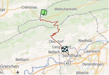
Trail Cycle of 15.3 km to be discovered at Solothurn, Bezirk Thal, Welschenrohr-Gänsbrunnen. This trail is proposed by LCGsell.

Description

Fünfte Strecke der Etappe 010CH07 von Basel nach Biel
Es sei denn, die steile Strasse auf den Weissenstein sei nicht zu gross ein Hindernis. Dann geht es zum Dorf Gänsbrunnen und durch die Kurve hinaus und bald rechts in die kleine Strasse zum Weissenstein ( Eine begehrte Schlittelstrasse im Winter ! ) Der Anstieg ist hart, alles durch den Wald ohne Aussicht. In der dritten Haarnadel ist man oben und die Sonnenterasse lädt ein zum Ausschwitzen, zur Aussicht, Erholung und Warten auf die Langsamen, die mit dem Sessellift hochkommen. Die Abfahrt nach Oberdorf ist sehr steil und die Felgen beginnen zu glühen. Von Oberdorf geht es nur noch durch bewohntes Gebiet hinunter nach Solothurn, zum Treffpunkt in der Altstadt, beim Bahnhof oder an der Aare bei der Schifflände.
Schnell: 1h30, langsam: 2h

Elevation profile

Positioning

Country:
Switzerland
Region :
Solothurn
Department/Province :
Bezirk Thal
Municipality :
Welschenrohr-Gänsbrunnen
Location:
Unknown
Start:(UTM)
383973 ; 5235724 (32T) N.

Trails nearby

Trail On foot Welschenrohr-Gänsbrunnen - Weissenstein – Passwang Weg - Photo
On foot
PRO

On foot

Medium
Welschenrohr-Gänsbrunnen, Solothurn, Bezirk Thal, Switzerland
16.8 km | 26 km-effort
5h 57min
No
Trail On foot Oberdorf (SO) - Planetenweg - Photo
On foot
PRO

On foot

Easy
Oberdorf (SO), Solothurn, Bezirk Lebern, Switzerland
9.9 km | 15.2 km-effort
3h 27min
No
Trail On foot Grandval - Raimeux sommet - fixme - Photo
On foot
PRO

On foot

Easy
Grandval, Bern, Bernese Jura administrative district, Switzerland
3.7 km | 5.3 km-effort
1h 12min
No
Trail On foot Corcelles (BE) - Le Petit Pré - Sur le Golat - Photo
On foot
PRO

On foot

Easy
Corcelles (BE), Bern, Bernese Jura administrative district, Switzerland
3.4 km | 5 km-effort
1h 8min
No
Trail Walking Welschenrohr-Gänsbrunnen - w09_thal1 - Photo
Walking
GUIDE+

Walking

Very easy
Welschenrohr-Gänsbrunnen, Solothurn, Bezirk Thal, Switzerland
15 km | 26 km-effort
4h 35min
No
Trail On foot Grandval - Grandval - Combe des Geais - Photo
On foot
PRO

On foot

Easy
Grandval, Bern, Bernese Jura administrative district, Switzerland
3.1 km | 4.6 km-effort
1h 2min
No
Trail Other activity Corcelles (BE) - Corcelles - Grandval - Photo
Other activity
Mangold

Other activity

Very easy
Corcelles (BE), Bern, Bernese Jura administrative district, Switzerland
11.6 km | 21 km-effort
Unknown
No
Trail Walking Grandval - Grandval gare - Chalet CMJ - Moutier gare - Photo
Walking
rebetez

Walking

Very easy
Grandval, Bern, Bernese Jura administrative district, Switzerland
11 km | 20 km-effort
4h 49min
No
Trail Other activity Crémines - Crémines - Les Golats - Photo
Other activity
rebetez

Other activity

Very easy
Crémines, Bern, Bernese Jura administrative district, Switzerland
13.5 km | 25 km-effort
Unknown
No


Close
My subscriptions