


lampertslochr woerth

anniston
User
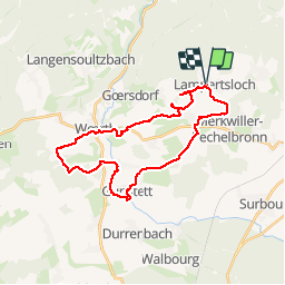

Length
28 km

Max alt
247 m

Uphill gradient
432 m
Km-Effort
34 km

Min alt
157 m

Downhill gradient
433 m
Boucle
Yes
Creation date :
2019-05-26 07:25:51.017
Updated on :
2019-05-26 14:16:00.396
5h30
Difficulty : Very easy

FREE GPS app for hiking
 SityTrail
IGN / Geographical institutes
SityTrail Plus
The world is yours!
About
Trail Horseback riding of 28 km to be discovered at Grand Est, Bas-Rhin, Lampertsloch. This trail is proposed by anniston.
Positioning
Country:
France
Region :
Grand Est
Department/Province :
Bas-Rhin
Municipality :
Lampertsloch
Location:
Unknown
Start:(Dec)
Start:(UTM)
413068 ; 5423416 (32U) N.
Comments