


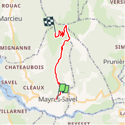
Le Senepy par Mayres Savel

claude nier
User

Length
7.7 km

Max alt
1765 m

Uphill gradient
1085 m
Km-Effort
18.6 km

Min alt
678 m

Downhill gradient
2 m
Boucle
No
Creation date :
2019-05-26 14:46:55.045
Updated on :
2019-05-26 14:49:08.301
4h13
Difficulty : Difficult

FREE GPS app for hiking
 SityTrail
IGN / Geographical institutes
SityTrail Plus
The world is yours!
About
Trail Walking of 7.7 km to be discovered at Auvergne-Rhône-Alpes, Isère, Mayres-Savel. This trail is proposed by claude nier.
Description
depart tres raide
on prends la cadance...
belle rando
Positioning
Country:
France
Region :
Auvergne-Rhône-Alpes
Department/Province :
Isère
Municipality :
Mayres-Savel
Location:
Unknown
Start:(Dec)
Start:(UTM)
715030 ; 4972599 (31T) N.
Comments