


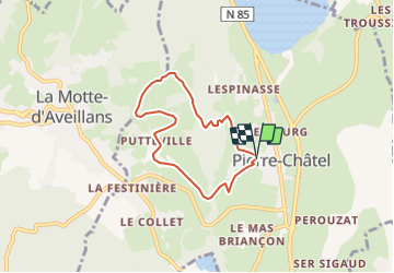
La Pierre Percee par Pierre Chatel

claude nier
User

Length
5.9 km

Max alt
1245 m

Uphill gradient
303 m
Km-Effort
9.9 km

Min alt
930 m

Downhill gradient
310 m
Boucle
Yes
Creation date :
2019-05-26 14:54:57.274
Updated on :
2019-05-26 14:56:44.684
2h01
Difficulty : Medium

FREE GPS app for hiking
 SityTrail
IGN / Geographical institutes
SityTrail Plus
The world is yours!
About
Trail Walking of 5.9 km to be discovered at Auvergne-Rhône-Alpes, Isère, Pierre-Châtel. This trail is proposed by claude nier.
Description
A decouvrir....
Positioning
Country:
France
Region :
Auvergne-Rhône-Alpes
Department/Province :
Isère
Municipality :
Pierre-Châtel
Location:
Unknown
Start:(Dec)
Start:(UTM)
718836 ; 4981868 (31T) N.
Comments