


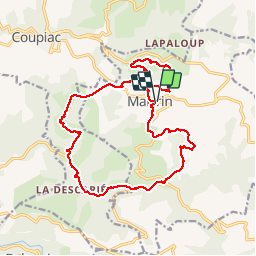
martrin.

Frayssinet
User

Length
18.7 km

Max alt
602 m

Uphill gradient
638 m
Km-Effort
27 km

Min alt
290 m

Downhill gradient
647 m
Boucle
Yes
Creation date :
2019-05-26 08:06:51.061
Updated on :
2019-05-26 14:56:53.312
6h02
Difficulty : Medium

FREE GPS app for hiking
 SityTrail
IGN / Geographical institutes
SityTrail Plus
The world is yours!
About
Trail Walking of 18.7 km to be discovered at Occitania, Aveyron, Martrin. This trail is proposed by Frayssinet.
Description
À venir
Positioning
Country:
France
Region :
Occitania
Department/Province :
Aveyron
Municipality :
Martrin
Location:
Unknown
Start:(Dec)
Start:(UTM)
469681 ; 4865061 (31T) N.
Comments