


Chantemelle 10 km wiki

Dom62
User
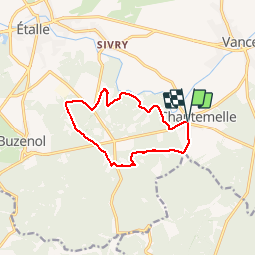

Length
10.3 km

Max alt
369 m

Uphill gradient
117 m
Km-Effort
11.8 km

Min alt
337 m

Downhill gradient
114 m
Boucle
Yes
Creation date :
2019-05-26 09:04:32.754
Updated on :
2019-05-26 15:59:07.052
2h09
Difficulty : Very easy

FREE GPS app for hiking
 SityTrail
IGN / Geographical institutes
SityTrail Plus
The world is yours!
About
Trail Walking of 10.3 km to be discovered at Wallonia, Luxembourg, Étalle. This trail is proposed by Dom62.
Positioning
Country:
Belgium
Region :
Wallonia
Department/Province :
Luxembourg
Municipality :
Étalle
Location:
Chantemelle
Start:(Dec)
Start:(UTM)
691388 ; 5503341 (31U) N.
Comments