


Massiac

betf
User
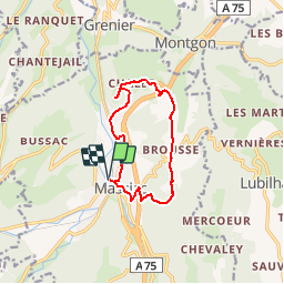

Length
10.8 km

Max alt
795 m

Uphill gradient
349 m
Km-Effort
15.5 km

Min alt
525 m

Downhill gradient
348 m
Boucle
Yes
Creation date :
2019-05-26 16:02:39.952
Updated on :
2019-05-26 16:48:42.176
3h25
Difficulty : Difficult

FREE GPS app for hiking
 SityTrail
IGN / Geographical institutes
SityTrail Plus
The world is yours!
About
Trail Walking of 10.8 km to be discovered at Auvergne-Rhône-Alpes, Cantal, Massiac. This trail is proposed by betf.
Description
La chapelle Ste-Madeleine
Positioning
Country:
France
Region :
Auvergne-Rhône-Alpes
Department/Province :
Cantal
Municipality :
Massiac
Location:
Unknown
Start:(Dec)
Start:(UTM)
515353 ; 5011132 (31T) N.
Comments