


M34 CALVISSON CONGENIES 26-05-2019

jeff66
User
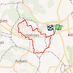

Length
14.1 km

Max alt
138 m

Uphill gradient
190 m
Km-Effort
16.6 km

Min alt
42 m

Downhill gradient
191 m
Boucle
Yes
Creation date :
2019-05-26 14:28:16.0
Updated on :
2019-05-26 17:30:39.49
2h34
Difficulty : Medium

FREE GPS app for hiking
 SityTrail
IGN / Geographical institutes
SityTrail Plus
The world is yours!
About
Trail Walking of 14.1 km to be discovered at Occitania, Gard, Calvisson. This trail is proposed by jeff66.
Positioning
Country:
France
Region :
Occitania
Department/Province :
Gard
Municipality :
Calvisson
Location:
Unknown
Start:(Dec)
Start:(UTM)
595751 ; 4847935 (31T) N.
Comments