


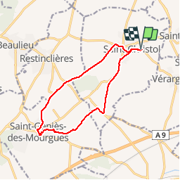
M34 - SAINT CHRISTOL - SAINT GÉNIES DES M. - le 27.10.2019

jeff66
User


2h26
Difficulty : Medium

FREE GPS app for hiking
 SityTrail
IGN / Geographical institutes
SityTrail Plus
The world is yours!
About
Trail Walking of 13.3 km to be discovered at Occitania, Hérault, Entre-Vignes. This trail is proposed by jeff66.
Description
ST CHRISTOL - parking viavino- stade - eglise - cave coop - Chemin grande traversée de l’Hérault - les coulondres - traverser RD171 - les Hugues - les Faroussieres - encornet - le mas de renard - StT GÉNIES DES M. - les Truques - le puits neuf - rue des carrières -église - rue de l’égalité cimetiére - rejoindre GR 653 - Chemin et croix de Missargues - dardaillon ouest - la bruyère - espace loisirs - emprunter RD171 - Longer canal - canal bas Rhône - station de pompage - manade Salvini - Mas pagnol - les ranquets - ST CHRISTOL - rue de l’église - descente des oliviers - Chemin dû Coulet - la glacière
Photos


Positioning
Comments