


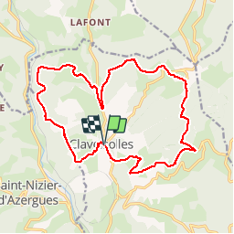
Claveisolles (19 km - D. 638 m)

Thomasdanielle
User


5h11
Difficulty : Unknown

FREE GPS app for hiking
 SityTrail
IGN / Geographical institutes
SityTrail Plus
The world is yours!
About
Trail Walking of 18.7 km to be discovered at Auvergne-Rhône-Alpes, Rhône, Claveisolles. This trail is proposed by Thomasdanielle.
Description
D/A : Parking salle des fêtes
Suivre le tracé "sapin vert" puis à la croix des moines à 1,5 km de claveisolles tourner sur la gauche et continuer le sentier jusqu'au village.
Belle randonnée, dommage que la première partie il a du goudron.
Positioning
Comments