Trail Walking Bolandoz - bolandoz Rochanon - Photo
© OpenStreetMap contributors
Length
Length
19 km
Max alt
Max alt
903 m
Uphill gradient
Uphill gradient
418 m
Km-Effort
Km-Effort  
25 km
Min alt
Min alt
633 m
Downhill gradient
Downhill gradient
422 m
Boucle
Boucle
Yes
Creation date :
2019-05-27 08:03:33.24
Updated on :
2019-12-07 19:52:36.718

(1 Reviews)

Walking
Walking
5h41
Difficulty : Easy

Scan this QR Code to open this trail in the SityTrail application

FREE GPS app for hiking

Logo SityTrail SityTrail

IGN / Geographical institutes

Download SityTrail from the App Store Download SityTrail from Google Play

Logo SityTrail SityTrail Plus

The world is yours!

Download SityTrail from the App Store Download SityTrail from Google Play Download SityTrail on Huawei AppGallery

About

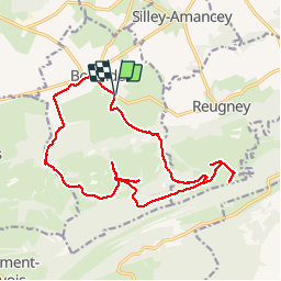
Trail Walking of 19 km to be discovered at Bourgogne-Franche-Comté, Doubs, Bolandoz. This trail is proposed by eltonnermou.

Description

randonnée en groupe.
A travers de belles prairies,  flore protégée et variée ; des points de vue qui réchauffent les yeux ; un dénivelé qui ne peut faire peur ; le tracé montre quelques erreurs d'orientation et réduit d'autant la distance affichée (en entête), environ 16km.

Elevation profile

Positioning

Country:
France
Region :
Bourgogne-Franche-Comté
Department/Province :
Doubs
Municipality :
Bolandoz
Location:
Unknown
Start:(UTM)
280979 ; 5210760 (32T) N.

Comments

Please log in to post a review or rate the element


Close
My subscriptions