


Autour de Lazer

claude nier
User
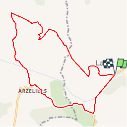

Length
10.6 km

Max alt
797 m

Uphill gradient
257 m
Km-Effort
14 km

Min alt
599 m

Downhill gradient
257 m
Boucle
Yes
Creation date :
2019-05-28 08:13:22.686
Updated on :
2019-05-28 08:14:50.871
2h59
Difficulty : Difficult

FREE GPS app for hiking
 SityTrail
IGN / Geographical institutes
SityTrail Plus
The world is yours!
About
Trail Walking of 10.6 km to be discovered at Provence-Alpes-Côte d'Azur, Hautes-Alpes, Lazer. This trail is proposed by claude nier.
Description
A faire..
Positioning
Country:
France
Region :
Provence-Alpes-Côte d'Azur
Department/Province :
Hautes-Alpes
Municipality :
Lazer
Location:
Unknown
Start:(Dec)
Start:(UTM)
726454 ; 4914173 (31T) N.
Comments