


Circuit d Upaix

claude nier
User
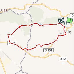

Length
7.2 km

Max alt
740 m

Uphill gradient
195 m
Km-Effort
9.8 km

Min alt
576 m

Downhill gradient
190 m
Boucle
Yes
Creation date :
2019-05-28 08:32:32.874
Updated on :
2019-05-28 08:33:50.808
2h05
Difficulty : Medium

FREE GPS app for hiking
 SityTrail
IGN / Geographical institutes
SityTrail Plus
The world is yours!
About
Trail Walking of 7.2 km to be discovered at Provence-Alpes-Côte d'Azur, Hautes-Alpes, Upaix. This trail is proposed by claude nier.
Description
a decouvrir
Positioning
Country:
France
Region :
Provence-Alpes-Côte d'Azur
Department/Province :
Hautes-Alpes
Municipality :
Upaix
Location:
Unknown
Start:(Dec)
Start:(UTM)
729228 ; 4911429 (31T) N.
Comments