


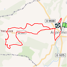
Circuit de Thuoux

claude nier
User

Length
10.8 km

Max alt
932 m

Uphill gradient
322 m
Km-Effort
15.1 km

Min alt
718 m

Downhill gradient
326 m
Boucle
Yes
Creation date :
2019-05-28 08:55:01.695
Updated on :
2019-05-28 08:55:48.228
3h10
Difficulty : Difficult

FREE GPS app for hiking
 SityTrail
IGN / Geographical institutes
SityTrail Plus
The world is yours!
About
Trail Walking of 10.8 km to be discovered at Provence-Alpes-Côte d'Azur, Hautes-Alpes, Aspremont. This trail is proposed by claude nier.
Description
A decouvrir
Positioning
Country:
France
Region :
Provence-Alpes-Côte d'Azur
Department/Province :
Hautes-Alpes
Municipality :
Aspremont
Location:
Unknown
Start:(Dec)
Start:(UTM)
716948 ; 4930364 (31T) N.
Comments