


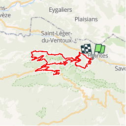
Mont ventoux par Mt Serein

veroarvinberod
User

Length
40 km

Max alt
1907 m

Uphill gradient
1614 m
Km-Effort
62 km

Min alt
484 m

Downhill gradient
1622 m
Boucle
Yes
Creation date :
2019-05-28 08:36:08.812
Updated on :
2019-05-28 14:36:51.605
5h58
Difficulty : Difficult

FREE GPS app for hiking
 SityTrail
IGN / Geographical institutes
SityTrail Plus
The world is yours!
About
Trail Mountain bike of 40 km to be discovered at Provence-Alpes-Côte d'Azur, Vaucluse, Brantes. This trail is proposed by veroarvinberod.
Positioning
Country:
France
Region :
Provence-Alpes-Côte d'Azur
Department/Province :
Vaucluse
Municipality :
Brantes
Location:
Unknown
Start:(Dec)
Start:(UTM)
685978 ; 4895452 (31T) N.
Comments