


Autour de Furmeyer

claude nier
User
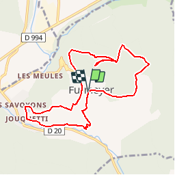

Length
9.7 km

Max alt
1308 m

Uphill gradient
585 m
Km-Effort
17.5 km

Min alt
859 m

Downhill gradient
591 m
Boucle
Yes
Creation date :
2019-05-28 16:12:06.153
Updated on :
2019-05-28 16:13:06.655
3h31
Difficulty : Difficult

FREE GPS app for hiking
 SityTrail
IGN / Geographical institutes
SityTrail Plus
The world is yours!
About
Trail Walking of 9.7 km to be discovered at Provence-Alpes-Côte d'Azur, Hautes-Alpes, Furmeyer. This trail is proposed by claude nier.
Description
depart apres le pont de Drouzet
Positioning
Country:
France
Region :
Provence-Alpes-Côte d'Azur
Department/Province :
Hautes-Alpes
Municipality :
Furmeyer
Location:
Unknown
Start:(Dec)
Start:(UTM)
728187 ; 4935820 (31T) N.
Comments