


CLD-MM- le 28/05/2019 (Hauterive))

JackPG
User
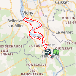

Length
12.6 km

Max alt
277 m

Uphill gradient
92 m
Km-Effort
13.8 km

Min alt
248 m

Downhill gradient
92 m
Boucle
Yes
Creation date :
2019-05-29 07:09:08.198
Updated on :
2019-05-29 07:09:59.247
3h04
Difficulty : Medium

FREE GPS app for hiking
 SityTrail
IGN / Geographical institutes
SityTrail Plus
The world is yours!
About
Trail Walking of 12.6 km to be discovered at Auvergne-Rhône-Alpes, Allier, Hauterive. This trail is proposed by JackPG.
Positioning
Country:
France
Region :
Auvergne-Rhône-Alpes
Department/Province :
Allier
Municipality :
Hauterive
Location:
Unknown
Start:(Dec)
Start:(UTM)
534701 ; 5103819 (31T) N.
Comments