Trail Walking Dinant - FURFFOZ ... les Aiguilles de Chaleux et la Réserve  naturelle. - Photo

FURFFOZ ... les Aiguilles de Chaleux et la Réserve naturelle.

© OpenStreetMap contributors
Length
Length
9.6 km
Max alt
Max alt
225 m
Uphill gradient
Uphill gradient
248 m
Km-Effort
Km-Effort  
12.9 km
Min alt
Min alt
94 m
Downhill gradient
Downhill gradient
250 m
Boucle
Boucle
Yes
Creation date :
2019-05-29 11:50:20.314
Updated on :
2019-06-02 08:58:38.873

(6 Reviews)

Walking
Walking
1h38
Difficulty : Easy

Scan this QR Code to open this trail in the SityTrail application

FREE GPS app for hiking

Logo SityTrail SityTrail

IGN / Geographical institutes

Download SityTrail from the App Store Download SityTrail from Google Play

Logo SityTrail SityTrail World

The world is yours!

Download SityTrail from the App Store Download SityTrail from Google Play Download SityTrail on Huawei AppGallery

About

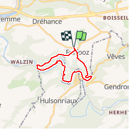
Trail Walking of 9.6 km to be discovered at Wallonia, Namur, Dinant. This trail is proposed by GerardBouche.

Description

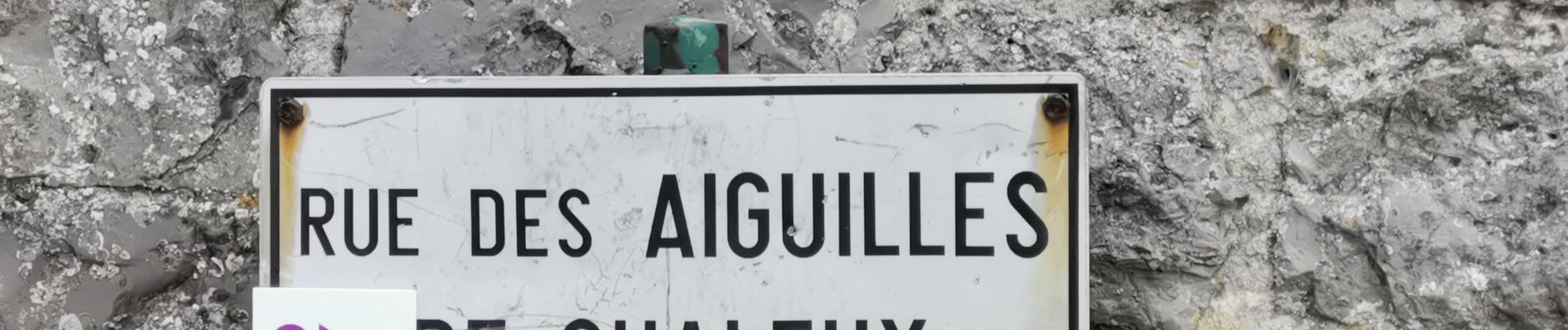
Très beau parcours par les Aiguilles de Chaleux et son superbe point de vue sur la vallée de la Lesse. La suite par le bois de Chaleux et sa Réserve Naturelle où une petite halte s'impose à " La FloBette " pour un réconfort ou une petite restauration sauvage ! Depuis Gendron-Celles la montée dans le " Flaya" est plutôt caillouteuse.

Elevation profile

Photos

Positioning

Country:
Belgium
Region :
Wallonia
Department/Province :
Namur
Municipality :
Dinant
Location:
Furfooz
Start:(UTM)
639629 ; 5565526 (31U) N.

Comments

Please log in to post a review or rate the element


Top


Belle randonnée mais à éviter les bords de Lesse et les kayaks en été


Parcours assez boueux et mal entretenu sur des endroits de friches le long de la Lesse Nous aurions pu profiter du décor magnifique offert par la nature si nous n’avions pas dû regarder en permanence où nous mettions les pieds


Rando un peu physique mais très belle le long de la lesse


Très belle


Trails nearby

Trail Walking Dinant - RB-Na-24-Entre Lesse et Meuse - Photo
Walking
PRO

Walking

Very difficult
(14)
Dinant, Wallonia, Namur, Belgium
19.3 km | 26 km-effort
5h 57min
Yes
Trail Walking Houyet - Nature - The Payenne trail (Houyet) - Photo
Walking
PRO

Walking

Difficult
(5)
Houyet, Wallonia, Namur, Belgium
14.3 km | 19 km-effort
4h 18min
Yes
Trail Walking Houyet - Nature - Royal Park walk - Houyet - Photo
Walking
PRO

Walking

Difficult
(14)
Houyet, Wallonia, Namur, Belgium
5.7 km | 7.8 km-effort
1h 47min
Yes
Trail Walking Houyet - Houyet - Pî-sinte po tortos - Walk for everyone -  On foot, by bicycle, on horseback, wheelchair accessible - Photo
Walking
PRO

Walking

(6)
Houyet, Wallonia, Namur, Belgium
4.3 km | 4.9 km-effort
1h 0min
Yes
Trail Walking Houyet - La Lesse, Natura 2000 - Des sites qui valent le détour, Na07 - Photo
Walking
GUIDE+

Walking

Difficult
(9)
Houyet, Wallonia, Namur, Belgium
8.8 km | 11.5 km-effort
2h 33min
Yes
Trail Walking Houyet - RB-Na-05 Hauts lieux de la basse Lesse - Photo
Walking
PRO

Walking

Medium
(8)
Houyet, Wallonia, Namur, Belgium
24 km | 31 km-effort
6h 33min
Yes
Trail Walking Houyet - Nature - Houyet, a royal municipality - Photo
Walking
PRO

Walking

Difficult
(14)
Houyet, Wallonia, Namur, Belgium
8.3 km | 11.5 km-effort
2h 33min
Yes
Trail Walking Houyet - RB-Na-05 Raccourci 1 - Hauts lieux de la basse Lesse - Photo
Walking
PRO

Walking

Easy
(5)
Houyet, Wallonia, Namur, Belgium
21 km | 26 km-effort
5h 37min
Yes
Trail Walking Houyet - Nature & heritage in Celles, one of the Most Beautiful Villages of Wallonia - Photo
Walking
PRO

Walking

Medium
(6)
Houyet, Wallonia, Namur, Belgium
9.6 km | 12.7 km-effort
2h 52min
Yes


Close
My subscriptions