


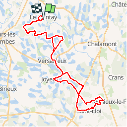
Plantay st Eloi

largajoolli
User

Length
46 km

Max alt
307 m

Uphill gradient
399 m
Km-Effort
51 km

Min alt
250 m

Downhill gradient
399 m
Boucle
Yes
Creation date :
2019-05-29 12:01:55.145
Updated on :
2019-05-29 16:09:10.24
3h45
Difficulty : Medium

FREE GPS app for hiking
 SityTrail
IGN / Geographical institutes
SityTrail Plus
The world is yours!
About
Trail Mountain bike of 46 km to be discovered at Auvergne-Rhône-Alpes, Ain, Le Plantay. This trail is proposed by largajoolli.
Positioning
Country:
France
Region :
Auvergne-Rhône-Alpes
Department/Province :
Ain
Municipality :
Le Plantay
Location:
Unknown
Start:(Dec)
Start:(UTM)
661745 ; 5098394 (31T) N.
Comments