


le Rozier-la Sablière 29-05-2019

avis12ex20b
User
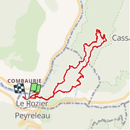

Length
10.1 km

Max alt
834 m

Uphill gradient
585 m
Km-Effort
18 km

Min alt
389 m

Downhill gradient
598 m
Boucle
Yes
Creation date :
2019-05-29 08:26:32.874
Updated on :
2019-05-29 16:26:12.678
5h29
Difficulty : Very easy

FREE GPS app for hiking
 SityTrail
IGN / Geographical institutes
SityTrail Plus
The world is yours!
About
Trail Walking of 10.1 km to be discovered at Occitania, Lozère, Le Rozier. This trail is proposed by avis12ex20b.
Positioning
Country:
France
Region :
Occitania
Department/Province :
Lozère
Municipality :
Le Rozier
Location:
Unknown
Start:(Dec)
Start:(UTM)
516517 ; 4893224 (31T) N.
Comments