


lamastre

guy07
User
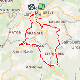

Length
18.7 km

Max alt
837 m

Uphill gradient
643 m
Km-Effort
27 km

Min alt
379 m

Downhill gradient
644 m
Boucle
Yes
Creation date :
2019-05-28 07:09:37.122
Updated on :
2019-05-29 17:40:13.562
6h46
Difficulty : Very easy

FREE GPS app for hiking
 SityTrail
IGN / Geographical institutes
SityTrail Plus
The world is yours!
About
Trail Walking of 18.7 km to be discovered at Auvergne-Rhône-Alpes, Ardèche, Lamastre. This trail is proposed by guy07.
Positioning
Country:
France
Region :
Auvergne-Rhône-Alpes
Department/Province :
Ardèche
Municipality :
Lamastre
Location:
Unknown
Start:(Dec)
Start:(UTM)
625051 ; 4982674 (31T) N.
Comments