


les Aigaux Bellecombe

raymondfn
User
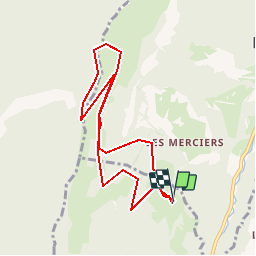

Length
8.8 km

Max alt
1688 m

Uphill gradient
514 m
Km-Effort
15.6 km

Min alt
1199 m

Downhill gradient
516 m
Boucle
Yes
Creation date :
2019-05-30 08:09:16.683
Updated on :
2019-05-30 08:13:08.322
3h09
Difficulty : Difficult

FREE GPS app for hiking
 SityTrail
IGN / Geographical institutes
SityTrail Plus
The world is yours!
About
Trail Walking of 8.8 km to be discovered at Auvergne-Rhône-Alpes, Isère, Lans-en-Vercors. This trail is proposed by raymondfn.
Positioning
Country:
France
Region :
Auvergne-Rhône-Alpes
Department/Province :
Isère
Municipality :
Lans-en-Vercors
Location:
Unknown
Start:(Dec)
Start:(UTM)
704272 ; 5004120 (31T) N.
Comments