


arlebox

guy07
User
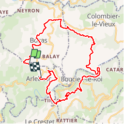

Length
21 km

Max alt
570 m

Uphill gradient
601 m
Km-Effort
29 km

Min alt
250 m

Downhill gradient
666 m
Boucle
No
Creation date :
2019-05-30 06:15:45.545
Updated on :
2019-05-30 13:03:14.19
4h54
Difficulty : Very easy

FREE GPS app for hiking
 SityTrail
IGN / Geographical institutes
SityTrail Plus
The world is yours!
About
Trail Walking of 21 km to be discovered at Auvergne-Rhône-Alpes, Ardèche, Arlebosc. This trail is proposed by guy07.
Positioning
Country:
France
Region :
Auvergne-Rhône-Alpes
Department/Province :
Ardèche
Municipality :
Arlebosc
Location:
Unknown
Start:(Dec)
Start:(UTM)
629539 ; 4989025 (31T) N.
Comments