


GR5_J17

michelelfn
User
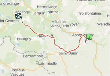

Length
17.5 km

Max alt
439 m

Uphill gradient
380 m
Km-Effort
23 km

Min alt
273 m

Downhill gradient
378 m
Boucle
No
Creation date :
2014-12-10 00:00:00.0
Updated on :
2014-12-10 00:00:00.0
5h00
Difficulty : Easy

FREE GPS app for hiking
 SityTrail
IGN / Geographical institutes
SityTrail Plus
The world is yours!
About
Trail Walking of 17.5 km to be discovered at Grand Est, Moselle, Saint-Quirin. This trail is proposed by michelelfn.
Description
GR5 J17
Positioning
Country:
France
Region :
Grand Est
Department/Province :
Moselle
Municipality :
Saint-Quirin
Location:
Unknown
Start:(Dec)
Start:(UTM)
360199 ; 5387415 (32U) N.
Comments