


montdore1

pidjam
User
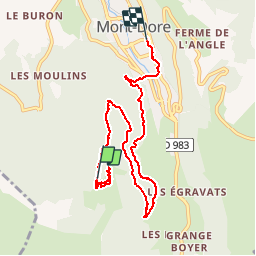

Length
8 km

Max alt
1453 m

Uphill gradient
157 m
Km-Effort
11.2 km

Min alt
1030 m

Downhill gradient
495 m
Boucle
No
Creation date :
2019-05-31 08:56:36.259
Updated on :
2019-05-31 10:57:54.75
1h59
Difficulty : Very easy

FREE GPS app for hiking
 SityTrail
IGN / Geographical institutes
SityTrail Plus
The world is yours!
About
Trail Walking of 8 km to be discovered at Auvergne-Rhône-Alpes, Puy-de-Dôme, Mont-Dore. This trail is proposed by pidjam.
Positioning
Country:
France
Region :
Auvergne-Rhône-Alpes
Department/Province :
Puy-de-Dôme
Municipality :
Mont-Dore
Location:
Unknown
Start:(Dec)
Start:(UTM)
484442 ; 5045173 (31T) N.
Comments
foutage de gueule rien est gratuit