


rando2019

andre.rochet.ar
User
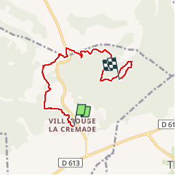

Length
6 km

Max alt
185 m

Uphill gradient
146 m
Km-Effort
7.8 km

Min alt
113 m

Downhill gradient
89 m
Boucle
No
Creation date :
2019-05-31 07:30:09.405
Updated on :
2019-05-31 13:46:26.251
2h48
Difficulty : Very easy

FREE GPS app for hiking
 SityTrail
IGN / Geographical institutes
SityTrail Plus
The world is yours!
About
Trail Walking of 6 km to be discovered at Occitania, Aude, Fabrezan. This trail is proposed by andre.rochet.ar.
Description
Radonnée faite le 10/06/2019 par le foyer des jeunes de Villerouge la Crémade

Positioning
Country:
France
Region :
Occitania
Department/Province :
Aude
Municipality :
Fabrezan
Location:
Unknown
Start:(Dec)
Start:(UTM)
478744 ; 4773279 (31T) N.
Comments