


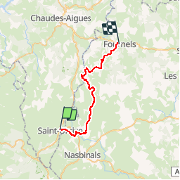
tour aubrac 6 st urcize fournels

mhetpierre
User

Length
31 km

Max alt
1179 m

Uphill gradient
620 m
Km-Effort
39 km

Min alt
957 m

Downhill gradient
774 m
Boucle
No
Creation date :
2019-05-31 06:43:13.415
Updated on :
2019-06-10 18:33:04.066
8h19
Difficulty : Very easy

FREE GPS app for hiking
 SityTrail
IGN / Geographical institutes
SityTrail Plus
The world is yours!
About
Trail Walking of 31 km to be discovered at Auvergne-Rhône-Alpes, Cantal, Saint-Urcize. This trail is proposed by mhetpierre.
Positioning
Country:
France
Region :
Auvergne-Rhône-Alpes
Department/Province :
Cantal
Municipality :
Saint-Urcize
Location:
Unknown
Start:(Dec)
Start:(UTM)
500250 ; 4949382 (31T) N.
Comments