


La Monta - Le Roux

motardes04
User

Length
11.9 km

Max alt
2583 m

Uphill gradient
972 m
Km-Effort
25 km

Min alt
1656 m

Downhill gradient
890 m
Boucle
No
Creation date :
2014-12-10 00:00:00.0
Updated on :
2014-12-10 00:00:00.0
4h59
Difficulty : Easy

FREE GPS app for hiking
 SityTrail
IGN / Geographical institutes
SityTrail Plus
The world is yours!
About
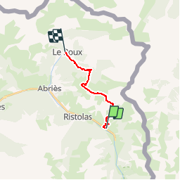
Trail Walking of 11.9 km to be discovered at Provence-Alpes-Côte d'Azur, Hautes-Alpes, Abriès-Ristolas. This trail is proposed by motardes04.
Description
Tour du Queyras étape 5 via GR58D
Positioning
Country:
France
Region :
Provence-Alpes-Côte d'Azur
Department/Province :
Hautes-Alpes
Municipality :
Abriès-Ristolas
Location:
Ristolas
Start:(Dec)
Start:(UTM)
340446 ; 4958953 (32T) N.
Comments