


HMN Meillac

PEGAM
User
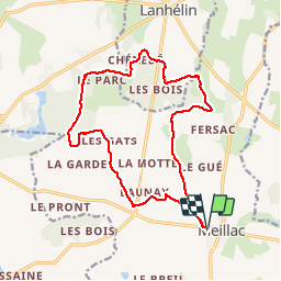

Length
15.9 km

Max alt
93 m

Uphill gradient
137 m
Km-Effort
17.7 km

Min alt
36 m

Downhill gradient
138 m
Boucle
Yes
Creation date :
2019-05-31 12:03:43.213
Updated on :
2019-06-01 08:59:54.443
3h31
Difficulty : Very easy

FREE GPS app for hiking
 SityTrail
IGN / Geographical institutes
SityTrail Plus
The world is yours!
About
Trail Walking of 15.9 km to be discovered at Brittany, Ille-et-Vilaine, Meillac. This trail is proposed by PEGAM.
Description
marche
Positioning
Country:
France
Region :
Brittany
Department/Province :
Ille-et-Vilaine
Municipality :
Meillac
Location:
Unknown
Start:(Dec)
Start:(UTM)
587611 ; 5362736 (30U) N.
Comments