


Tour deLA Fayee depart Chanousse

claude nier
User
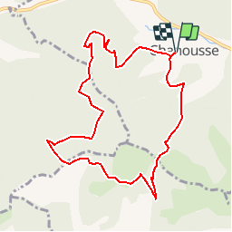

Length
10.1 km

Max alt
1156 m

Uphill gradient
540 m
Km-Effort
17.3 km

Min alt
779 m

Downhill gradient
540 m
Boucle
Yes
Creation date :
2019-06-01 11:06:10.715
Updated on :
2019-06-01 11:07:44.39
3h31
Difficulty : Difficult

FREE GPS app for hiking
 SityTrail
IGN / Geographical institutes
SityTrail Plus
The world is yours!
About
Trail Walking of 10.1 km to be discovered at Provence-Alpes-Côte d'Azur, Hautes-Alpes, Chanousse. This trail is proposed by claude nier.
Description
a decouvrir...
Positioning
Country:
France
Region :
Provence-Alpes-Côte d'Azur
Department/Province :
Hautes-Alpes
Municipality :
Chanousse
Location:
Unknown
Start:(Dec)
Start:(UTM)
711611 ; 4914733 (31T) N.
Comments