


Paris 2024 n•1

VANDERPUTTENMi
User GUIDE
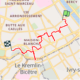

Length
6.5 km

Max alt
66 m

Uphill gradient
92 m
Km-Effort
7.7 km

Min alt
30 m

Downhill gradient
71 m
Boucle
No
Creation date :
2019-06-01 14:32:38.073
Updated on :
2019-06-01 16:44:36.782
1h58
Difficulty : Very easy

FREE GPS app for hiking
 SityTrail
IGN / Geographical institutes
SityTrail Plus
The world is yours!
About
Trail Walking of 6.5 km to be discovered at Ile-de-France, Paris, Paris. This trail is proposed by VANDERPUTTENMi.
Positioning
Country:
France
Region :
Ile-de-France
Department/Province :
Paris
Municipality :
Paris
Location:
13th Arrondissement
Start:(Dec)
Start:(UTM)
454184 ; 5408755 (31U) N.
Comments