


05.08.2013 - Rophemel

babeth35
User
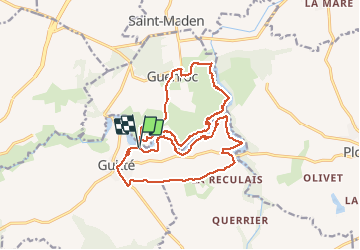

Length
21 km

Uphill gradient
3787 m
Km-Effort
72 km

Downhill gradient
3811 m
Boucle
Yes
Creation date :
2014-12-10 00:00:00.0
Updated on :
2020-07-20 16:14:06.234
6h11
Difficulty : Medium

FREE GPS app for hiking
 SityTrail
IGN / Geographical institutes
SityTrail Plus
The world is yours!
About
Trail Walking of 21 km to be discovered at Brittany, Côtes-d'Armor, Guitté. This trail is proposed by babeth35.
Positioning
Country:
France
Region :
Brittany
Department/Province :
Côtes-d'Armor
Municipality :
Guitté
Location:
Unknown
Start:(Dec)
Start:(UTM)
567660 ; 5350165 (30U) N.
Comments