


pannessiere

nicolas.gx
User
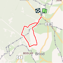

Length
4.8 km

Max alt
567 m

Uphill gradient
73 m
Km-Effort
5.8 km

Min alt
532 m

Downhill gradient
72 m
Boucle
Yes
Creation date :
2019-06-01 13:27:53.114
Updated on :
2019-06-02 08:09:12.43
59m
Difficulty : Easy

FREE GPS app for hiking
 SityTrail
IGN / Geographical institutes
SityTrail Plus
The world is yours!
About
Trail Walking of 4.8 km to be discovered at Bourgogne-Franche-Comté, Jura, Perrigny. This trail is proposed by nicolas.gx.
Description
promenade dans les bois de pannessiere
Positioning
Country:
France
Region :
Bourgogne-Franche-Comté
Department/Province :
Jura
Municipality :
Perrigny
Location:
Unknown
Start:(Dec)
Start:(UTM)
700680 ; 5172876 (31T) N.
Comments