


2019 06 02 Col de la Croix

psesjs
User
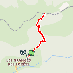

Length
3.6 km

Max alt
1491 m

Uphill gradient
275 m
Km-Effort
7.2 km

Min alt
1216 m

Downhill gradient
274 m
Boucle
Yes
Creation date :
2019-06-02 07:42:32.559
Updated on :
2019-06-02 10:07:59.475
1h58
Difficulty : Difficult

FREE GPS app for hiking
 SityTrail
IGN / Geographical institutes
SityTrail Plus
The world is yours!
About
Trail Walking of 3.6 km to be discovered at Auvergne-Rhône-Alpes, Drôme, Lus-la-Croix-Haute. This trail is proposed by psesjs.
Description
Après une montée un peu raide, magnifique panorama sur Vercors, Chartreuse, Trièves
Photos

Positioning
Country:
France
Region :
Auvergne-Rhône-Alpes
Department/Province :
Drôme
Municipality :
Lus-la-Croix-Haute
Location:
Unknown
Start:(Dec)
Start:(UTM)
719912 ; 4952333 (31T) N.
Comments