Trail Walking Saint-Suliac - randonnée de St Suliac - Photo

randonnée de St Suliac

 slm3005
slm3005

User

© OpenStreetMap contributors
Length
Length
14.3 km
Max alt
Max alt
71 m
Uphill gradient
Uphill gradient
209 m
Km-Effort
Km-Effort  
17.1 km
Min alt
Min alt
0 m
Downhill gradient
Downhill gradient
222 m
Boucle
Boucle
No
Creation date :
2014-12-10 00:00:00.0
Updated on :
2014-12-10 00:00:00.0

(0 Reviews)

Walking
Walking
4h35
Difficulty : Very easy

Scan this QR Code to open this trail in the SityTrail application

FREE GPS app for hiking

Logo SityTrail SityTrail

IGN / Geographical institutes

Download SityTrail from the App Store Download SityTrail from Google Play

Logo SityTrail SityTrail World

The world is yours!

Download SityTrail from the App Store Download SityTrail from Google Play Download SityTrail on Huawei AppGallery

About

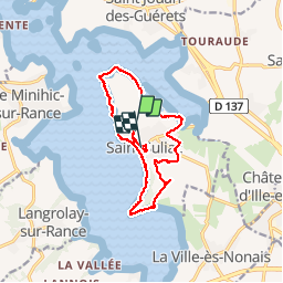
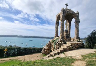
Trail Walking of 14.3 km to be discovered at Brittany, Ille-et-Vilaine, Saint-Suliac. This trail is proposed by slm3005.

Description

Entre bord de Rance et chemins boisés.

Elevation profile

Photos

Points of interest

Point of interest Saint-Suliac - Point 2 - Photo
slm3005
SAINT-SULIAC 
Point of interest Saint-Suliac - oratoire  - Photo
slm3005
SAINT-SULIAC 
Point of interest Saint-Suliac - Tregondé - Photo
slm3005
SAINT-SULIAC 
Point of interest Saint-Suliac - st jouan des guérets  - Photo
slm3005
Point of interest Saint-Jouan-des-Guérets - Ancien moulin à marée.  - Photo
slm3005
SAINT-JOUAN-DES-GUÉRETS 
Point of interest Saint-Suliac - ancien moulin - Photo
slm3005
SAINT-SULIAC 
Point of interest Saint-Suliac - lavoir.  - Photo
slm3005
SAINT-SULIAC 
Point of interest Saint-Suliac - pont de la ville-es-nonais - Photo
slm3005
Point of interest Saint-Suliac - Vestige Camp Viking - Photo
slm3005
SAINT-SULIAC 
Point of interest Saint-Suliac - Le Clos de Garo - Photo
slm3005
SAINT-SULIAC 
Point of interest Saint-Suliac - le Clos de Garo - Photo
slm3005
SAINT-SULIAC 
Point of interest Saint-Suliac - St. Suliac - Photo
slm3005
SAINT-SULIAC 

Positioning

Country:
France
Region :
Brittany
Department/Province :
Ille-et-Vilaine
Municipality :
Saint-Suliac
Location:
Unknown
Start:(UTM)
575537 ; 5380545 (30U) N.

Trails nearby

Trail Walking Saint-Suliac - St-Suliac.....Mordreuc - Photo
Walking
Bernardroland

Walking

Medium
(1)
Saint-Suliac, Brittany, Ille-et-Vilaine, France
17.5 km | 20 km-effort
4h 40min
No
Trail Walking Saint-Jouan-des-Guérets - les guérets de saint jouan - Photo
Walking
yannmarie22

Walking

Very easy
(3)
Saint-Jouan-des-Guérets, Brittany, Ille-et-Vilaine, France
10.2 km | 11.6 km-effort
2h 51min
Yes
Trail Mountain bike La Richardais - la richardais - Photo
Mountain bike
nsgautier

Mountain bike

Medium
(1)
La Richardais, Brittany, Ille-et-Vilaine, France
42 km | 48 km-effort
2h 41min
Yes
Trail Walking La Richardais - Du barrage à Cancaval - Photo
Walking
zefreefly

Walking

Very easy
La Richardais, Brittany, Ille-et-Vilaine, France
11.7 km | 13.5 km-effort
2h 53min
Yes
Trail Walking Saint-Suliac - Saint-Suliac les bords de la Rance - Photo
Walking
zefreefly

Walking

Very easy
Saint-Suliac, Brittany, Ille-et-Vilaine, France
20 km | 24 km-effort
4h 54min
Yes
Trail Walking Saint-Suliac - Petite boucle autour de Saint Suliac J6 - Photo
Walking
chessyca

Walking

Easy
Saint-Suliac, Brittany, Ille-et-Vilaine, France
5.9 km | 7.5 km-effort
1h 49min
Yes
Trail Walking Saint-Suliac - Balade découverte de Saint Souliac (hors groupe) - Photo
Walking
chessyca

Walking

Easy
Saint-Suliac, Brittany, Ille-et-Vilaine, France
4.6 km | 5.4 km-effort
1h 9min
Yes
Trail Walking Saint-Jouan-des-Guérets - Boucle Saint Jouan des Guérets St Elier - Photo
Walking
chessyca

Walking

Very easy
Saint-Jouan-des-Guérets, Brittany, Ille-et-Vilaine, France
8.6 km | 9.9 km-effort
2h 24min
Yes
Trail Walking Le Minihic-sur-Rance - Autour de Le Minihic sur Rance - Photo
Walking
chessyca

Walking

Very easy
Le Minihic-sur-Rance, Brittany, Ille-et-Vilaine, France
7.9 km | 9.1 km-effort
2h 15min
No


Close
My subscriptions