


Boucle du Roc Taillefer

claude nier
User
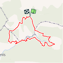

Length
9.2 km

Max alt
1066 m

Uphill gradient
410 m
Km-Effort
14.6 km

Min alt
746 m

Downhill gradient
410 m
Boucle
Yes
Creation date :
2019-06-02 14:14:12.241
Updated on :
2019-06-02 14:14:54.95
3h00
Difficulty : Difficult

FREE GPS app for hiking
 SityTrail
IGN / Geographical institutes
SityTrail Plus
The world is yours!
About
Trail Walking of 9.2 km to be discovered at Provence-Alpes-Côte d'Azur, Hautes-Alpes, Savournon. This trail is proposed by claude nier.
Description
a decouvrir
Positioning
Country:
France
Region :
Provence-Alpes-Côte d'Azur
Department/Province :
Hautes-Alpes
Municipality :
Savournon
Location:
Unknown
Start:(Dec)
Start:(UTM)
722537 ; 4920074 (31T) N.
Comments