


cerdon cublaise labalme cerdon

lemarinelr
User
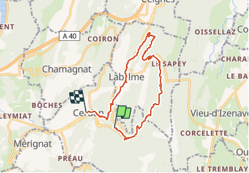

Length
14.3 km

Max alt
881 m

Uphill gradient
557 m
Km-Effort
22 km

Min alt
314 m

Downhill gradient
628 m
Boucle
No
Creation date :
2019-06-02 08:41:21.812
Updated on :
2019-06-02 15:52:27.242
4h27
Difficulty : Medium

FREE GPS app for hiking
 SityTrail
IGN / Geographical institutes
SityTrail Plus
The world is yours!
About
Trail Walking of 14.3 km to be discovered at Auvergne-Rhône-Alpes, Ain, Cerdon. This trail is proposed by lemarinelr.
Positioning
Country:
France
Region :
Auvergne-Rhône-Alpes
Department/Province :
Ain
Municipality :
Cerdon
Location:
Unknown
Start:(Dec)
Start:(UTM)
691578 ; 5105376 (31T) N.
Comments