Trail Walking Valserres - Chapelle Saint Maurice.  - Photo
© OpenStreetMap contributors
Length
Length
12.9 km
Max alt
Max alt
1366 m
Uphill gradient
Uphill gradient
741 m
Km-Effort
Km-Effort  
23 km
Min alt
Min alt
622 m
Downhill gradient
Downhill gradient
814 m
Boucle
Boucle
No
Creation date :
2019-06-02 12:46:19.807
Updated on :
2019-06-02 17:03:03.063

(0 Reviews)

Walking
Walking
3h51
Difficulty : Medium

Scan this QR Code to open this trail in the SityTrail application

FREE GPS app for hiking

Logo SityTrail SityTrail

IGN / Geographical institutes

Download SityTrail from the App Store Download SityTrail from Google Play

Logo SityTrail SityTrail Plus

The world is yours!

Download SityTrail from the App Store Download SityTrail from Google Play Download SityTrail on Huawei AppGallery

About

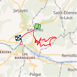
Trail Walking of 12.9 km to be discovered at Provence-Alpes-Côte d'Azur, Hautes-Alpes, Valserres. This trail is proposed by Dervalmarc.

Description

Attention randonnée très mal balise.
Suivre bien les quelques cairns aux intersections de la piste.
Privilégier la piste à la montée.
Le sentier rando très raide avec des pentes à plus de 40 pour cent.
Prudence à la descente surtout s'il a plu.
Rando sportive de moyen à difficile.

Elevation profile

Photos

Positioning

Country:
France
Region :
Provence-Alpes-Côte d'Azur
Department/Province :
Hautes-Alpes
Municipality :
Valserres
Location:
Unknown
Start:(UTM)
271424 ; 4929848 (32T) N.


Close
My subscriptions