


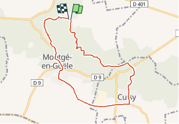
SityTrail - Montgé en Goële SuperMiniRando

GR77LP
User

Length
8 km

Max alt
188 m

Uphill gradient
133 m
Km-Effort
9.7 km

Min alt
111 m

Downhill gradient
131 m
Boucle
Yes
Creation date :
2019-06-03 07:42:27.849
Updated on :
2025-01-23 16:33:43.604
2h12
Difficulty : Medium

FREE GPS app for hiking
 SityTrail
IGN / Geographical institutes
SityTrail Plus
The world is yours!
About
Trail Walking of 8 km to be discovered at Ile-de-France, Seine-et-Marne, Montgé-en-Goële. This trail is proposed by GR77LP.
Description
Découvrir la forêt de Montgé en Goële
Photos

Positioning
Country:
France
Region :
Ile-de-France
Department/Province :
Seine-et-Marne
Municipality :
Montgé-en-Goële
Location:
Unknown
Start:(Dec)
Start:(UTM)
481956 ; 5431692 (31U) N.
Comments
rien 🤣🤣🤣🤣