


Trace HDT conplet

olivieraron
User
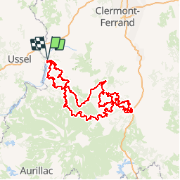

Length
390 km

Max alt
1460 m

Uphill gradient
10207 m
Km-Effort
526 km

Min alt
519 m

Downhill gradient
10207 m
Boucle
Yes
Creation date :
2019-06-03 11:04:33.736
Updated on :
2019-06-14 20:19:25.372
10h00
Difficulty : Difficult

FREE GPS app for hiking
 SityTrail
IGN / Geographical institutes
SityTrail Plus
The world is yours!
About
Trail Moto cross of 390 km to be discovered at Auvergne-Rhône-Alpes, Puy-de-Dôme, Singles. This trail is proposed by olivieraron.
Points of interest


Positioning
Country:
France
Region :
Auvergne-Rhône-Alpes
Department/Province :
Puy-de-Dôme
Municipality :
Singles
Location:
Unknown
Start:(Dec)
Start:(UTM)
464294 ; 5043371 (31T) N.
Comments